Quiz 2
Aeolian – Characterized by a sighing or moaning sound as if produced by the wind.
Spinifex – genus of perennial coastal grasses. They are one of the most common plants that grow in sand dunes along the coasts
Constructive waves – a low height, low frequency wave where the net movement of material is up the beach as the swash is stronger than the backwash.
Corrasion – The wave action moves rock and other material across the rock shelf and wears away the rock in an abrasive fashion.
Corrosion – In rocks along the coast there are minerals like iron. When waves break they wet the rocks. As the rock dries the salt in the sea water crystallises and acts on the minerals in the rock to erode material.
Refraction – When waves bend due to headlands and the contours of the ocean floor
Deposition – process by which material is added to a landform or land mass.
Destructive waves – found on steep beaches, are steeply breaking and mainly responsible for coastal erosion. Their backwash is much stronger than their swash.
Erosion – The process of eroding or being eroded by wind, water, or other natural agents
Hydraulic action – form of erosion caused by the force of moving water currents rushing into a crack in the rockface.
Longshore drift – The movement of material along a coast by waves that approach at an angle to the shore but recede directly away from it
Wednesday, October 26, 2011
7.3 Questions
7.3 Question
1. Name the three key geographical processes that shape the coastal environment.
The three key geographical processes that shape the coastal environment are erosion, transportation and deposition.
2. What is wave refraction and why does it occur?
Wave refraction causes the wave energy to be concentrated in particular areas and less intense in others. It occurs because wave energy is distributed evenly along the entire wave.
3. Use a diagram to explain how wave refection leads to the uneven distribution of wave energy along the coastline.
4. Name the most common erosional landforms found along the coastline.
The most common erosion landforms found along the coastline are around headlands.
5. Describe the three wave action processes that shape headlands.
The three wave action processes are hydraulic action, corrosion and corrosion
6. Explain the operation of the erosion-accretion cycle.
7. Name the three forces that shape depositional landforms on beaches
The three forces are wind, waves and prevailing ocean currents
8. Name the most common depositional landforms found along the coastline.
The most common depositional landform is beaches
9. Explain the process that forms coastal dunes. What role does vegetation play in their formation?
Coastal dunes are formed by the action of the wind. Once sand is deposited on the beach it is then subject to wind transportation. The wind blows the sand landward, which is then trapped by low-lying vegetation like coastal spinifex. The fore dune is a store of sand. It may be eroded away or it may continue to increase the size depending on wave and wind action.
10. Describe the process of longshore drift. What role does this process play in transporting sand along the coast?
Waves usually approach the coast at an angle. Once the waves break they start to lose their energy. As the swash travels up the beach it slows until the force of gravity causes it to travel directly back towards the ocean. The water will then be hit by the next wave and the process begins again.
11.
12. What role does the fordune play in protecting coastal areas?
The fordune provides a buffer zone for the fragile dune vegetation located on the hind dunes
13. a) On the Great Ocean Road in Victoria
b) Because it is up to 20 million years old
c) They were created by the sea gradually eroding the soft limestone cliffs
d) It collapsed
e) No, because you cannot stop constant water hitting rocks
14. Describe the twelve apostles
The twelve apostles are up to 20 million years old. They were created by the sea gradually eroding the soft limestone cliffs. Eventually, theses rocks will collapse as the water will be constantly eroding the rock.
15.
The local council has decided to buy back residential property located on a headland and a neighboring fordune that is subject to severe erosion. Local residents who own the property strongly disagree with the council as they believe it will deprive them of their spectacular views, relaxed lifestyle and valuable property. The council ignored the resident’s opinions and forced the residents to sell it. On 29th October 2011, the council bought the fordune. The council is trying is now trying recover the fordune from eroding and doing so successfully. Though, the residents aren’t happy.
Sunday, October 23, 2011
Cortes Bank

Cortes Bank is a dangerously shallow chain of underwater mountains in the Pacific Ocean. It is located about 188 kilometers west of Point Loma San Diego, USA, and about 82 kilometers south-west of San Clemente Island. It is in the middle of the ocean. Cortes Bank was originally a California channel island 10,000 years ago but when the Ice Age came, it lowered the sea level by 400 feet. The end result was Cortes Bank.
There is a model of the underground mountain at Cortes Bank:

Here is a bird's eye view of Cortes Bank:

This spot is capable of producing some amazing waves due to its location. Cortes Bank reaches a peak of about 30 kilometers long and rises from the ocean floor from about 1kilometer down. Some of the peaks come to just 1-2 meters below the surface at Bishop Rock, depending on the tides. The peaks are a hazard to large ships. Because it is located so far off the coast, there is really no limit to the amount of swell that can pass by this spot.The waves at Cortes Bank signal danger on the underwater rocks and are so big they show up on radar.
The location of Cortes Bank is shown below:

Bishop Rock, which is one of the jagged peaks in the underwater chain, rises to within 1 to 2 meters of the surface. This place has been known to ocean-going ship captains and fishermen for years.
Here is an example of how big the waves at Cortes Bank get:

To get the biggest waves at Cortes Bank, you need perfect conditions. Cortes Bank requires light winds, low tides and big storm swells from the northwest in order to reach its full potential. This surf spot is also a place where rough sea storms take place.
These need to happen all at the same time. This happened on 19th January 2001, where California's surfers went to test their skills against the biggest wave every ridden. These waves were traveling so fast that the surfers couldn't catch up to the wave paddling, instead they had to get there by a jet skier who towed them with a rope until they were moving fast enough to engage the wave. Surfers measure the waves from the back and the biggest wave of the day was 30 feet according to their measurements. A watcher on the other side, said he saw waves up to sixty feet tall.
This link to a video explains Cortes Bank in more detail:
http://www.surfline.com/surflinetv/how-it-works/how-it-works-cortes-bank_22567
Sunday, October 16, 2011
Defining Words 7.1,7.2
7.1
Breakwaters - A barrier built out into the sea to protect a coast or harbour from the force of waves.
Faecal coliform - aerobic bacteria found in the colon or faeces, often used as indicators of faecal contamination of water supplies.
Silting - A sedimentary material consisting of very fine particles intermediate in size between sand and clay.
Tidal Flushing - action of saltwater entering an estuary twice a day during the high tides.
Sea change - Sea Change is when people move from the city to start a new life by the sea
Urban stormwater – pure rainwater plus anything the rain carries along with it.
Dredging - Clean out the bed of (a harbor, river, or other area of water) by scooping out mud, weeds, and rubbish with a dredge.
Introduced plants – plants that come from difference countries
7.2
Ground swell - A large or extensive swell in the sea
Plunging waves – break on beaches where the slope is moderately steep.
Spilling waves – break far from the shore on beaches with gentle slopes
Surging waves – occur on very steep beaches. The waves roll up the steep face rather than breaking over it
Wind swell - waves generated by local winds
Wave height - The vertical distance between the trough and the crest of a wave
Wavelength - The distance between successive crests of a wave
Fetch - The distance traveled by wind or waves across open water
Surf - The mass or line of foam formed by waves breaking on a seashore or reef
Swash zone - an area of a beach where water washes up on shore after an incoming wave has broken.
Friday, October 14, 2011
7.2 questions
7.2 Questions
1. Outline the three stages in the formation of a wave.
First the wind forms ripples, then these form wavelets and finally waves. As the waves travel towards the coast they take the energy from the wind with them. When the waves enter shallow water the energy in the waves starts to interact with the sea floor
2. What is the fetch? Why is it an important factor in determining the size and speed of a wave?
The fetch is the distance the wind travels over the ocean to form a wave. The size and speed of the waves is influenced by the strength of the wind and the length of the fetch.
3. How do waves in the open ocean differ from waves closer to the shore?
Waves that are closer to the shore have a slower wave speed as a wave further from the shore.
4. Draw an annotated diagram showing wavelength and wave height.

5. Draw and annotated diagram explaining how a wave breaks.

6. Explain the difference between the three different types of waves
Spilling waves break from the shore on beaches with gentle slopes.
Plunging waves break on beaches where the slope is moderately steep
Surging waves occur on very steep beaches
7. Explain the difference between a wind swell and a ground swell
A wind swell is marked by a short wavelength and high frequency of waves hitting the coast while a ground swell forms when waves have travelled across a greater distance of ocean before hitting the coast.
8. Interpret the synoptic charts that tracked Tropical Cyclone Wati in the Coral Sea from 24-28 March 2006
Strong winds caused by Topical Cyclone Wati and the associated low pressure system formed a huge ground swell that hit Sydney
9. A tourist to Australia has asked you to advise them on the best areas for swimming at local beaches. Write a letter that explains to them the three types of waves and how to identify them.
Dear Tourist,
There are three different types of waves you need to look out for. The first type of wave is called spilling waves. These are great for body surfing as the waves are very gently. Personally I would prefer this type of wave. The second type of wave is called Plunging waves. These are great for experience suffers because of the tubes they form. The last type of wave is called surging waves. These waves roll up the steep face rather than breaking over it. I would suggest not to go to a beach with these waves.
10. Imagine you are the life saver on duty at busy Sydney beach during a large cyclone swell. Write an account of the day’s events.
Day 1 of the cyclone swell: the storm is absolutely terrible. It incredibly winding and the waves look dangerous. Luckily the beach is closed otherwise someone may get injured. It is presumed that this cyclone swell will end tomorrow
Day 2: the storm has stopped leaving beautiful sunning weather.
Thursday, October 13, 2011
7.1 Questions
7.1 Questions
1. Describe how the settlement pattern of Australia is related to issues in the coastal environment.
Some of the issues in the coastal environment caused by settlement pattern of Australia include pollution, tourism and recreational pressures, population growth, coastal rivers and lagoons, introduced plants, influencing decision-making and inappropriate development.
2. Why is the sustainable development of the coastline the aim of coastal management strategies?
All these issues has had a negative impact on the coastline therefore having a sustainable coastline means that it will improve these issues.
3. What trend has been labelled sea change?
The trend that has been labelled sea change is the process where overdevelopment and rapid growth of coastal areas occur due to the current Australian trend for people to move from large cities to smaller coastal town and villages where the lifestyle is more relaxed.
4. Describe one government response to sea change
Some town along the east coast of Australia have imposed residential caps
5. Select four of the geographical issues facing the coastal environment presented in this unit. For each issue identify the human actions that cause the issue
i. Pollution: the increase of urban development has led to an increase of pollution
ii. Population growth: overdevelopment and rapid growth of coastal areas
iii. Inappropriate development: a lot of inappropriate building has been built around the coastal environment mainly of the view.
iv. Tourism and Recreational Pressures: Humans increase the population during holidays placing pressure on the infrastructure and the environment surrounding the area.
6. What role do geographers play in developing management solutions to issues in coastal environments?
Geographers role in developing management solutions to issues in coastal environments is to find out what has changed now by referring to the past and how can it be improved in the future.
7.
B) The construction of these buildings is a great advantage for me. The beautiful view is absolutely stunning. I’ve been living here for about 5 years and so far I feel like a millionaire. The only problem about living here is that there will be an increase number of tourism in the holidays which can ruin your trip to the beach as there are too many people. Overall, I really enjoy living here and probably stay here till I die.
Monday, September 12, 2011
pg 117: 1-12a-f (9A2 - Due Fri 16/9) (9B2 Due - Tue 13/9)
pg 117: 1-12a-f (9A2 - Due Fri 16/9) (9B2 Due - Tue 13/9)
1. Name one federal and one state government department that fund and help with projects in small and regional towns.
• One federal fund is the Australian Government’s Department of Transport
• One State fund is the NSW Department
2. Name two government programs that Gulargambone has used to receive funding for various projects.
The two government programs that Gulargambone has used to receive funding include the Townlife Development Program and The Regional Partnerships program.
3. What is a rural transaction centre and why is it important?
It is a project that allows rural and remote communities to introduce new services, or group together existing services into one location: this assists with sustainable and increased services to the region.
4. What services does the GRTC offer?
The GRTC offers Giropost, Centrelink, Medicare, Internet access and the Reliance Credit Union along with the usual postal services and a small, but modern gift shop.
5. How have community groups responded to change in Gulargambone?
The community groups have responded in positive way. They have formed into community groups. These groups have lobbied government and non-government organisations for funding and assistance.
6. Give three examples of specific actions and strategies the Gulargambone Flying Ahead group has implemented in response to changes.
i. To increase the population and services that are available
ii. To improve the visual appearance of the town
iii. To promote Gulargambone
7. What was the purpose of the two eight two eight project?
The two eight two eight project involved the restoration of the former picture theatre into a vibrant and multifaceted community centre.
8. Outline some examples of active citizenship in the achievements that Gulargambone has made since 2000.
Some examples of the achievements include
• The opening of the Rural Transaction Centre and the first community-owned post office in Australia
• Lobbying for and receiving a new multi-purpose helath centre
• The purchase and renovation of the old picture theatre
9. Outline the role of the local government, Coonamble Shire Council, in the implementation of the Gulargambone Flying Ahead program
Coonamble Shire Council has been supportive of the Gulargambone Flying Ahead program and has provided financial assistance for many of the projects.
10. View the before and after photos in 4.24. Describe the changes that have taken place to renew and renovate this area.
In the before and after photos we can see many good changes. The before picture shows a very dull and boring building and has a feeling that it is unsafe to enter. The after photo looks more modern and cleaning and feels safer to enter.
11. In a paragraph discuss the importance of active citizenship in small communities like Gulargambone.
Active citizenship is very important to small communities such as Gulargambone because it gives them the right to do more things. These things include:
• all individuals and groups have the right to engage in the creation and re-creation of that democratic society
• have the right to participate in all of the democratic practices and institutions within that society
• Have the responsibility to ensure a broad definition of the political includes all relationships and structures throughout the social arrangement.
12. Read the news article?
a) The article is about how Gulargambone has become what it is now
b) According to the writer the causes of decline in Gulargambone is the collapse of their economy and the ravages of the drought
c) The impacts of the decline include the collapse of business as shops, banks, petrol stations and other services were removed and closed down.
d) The thing that caused the community to galvanise into action was the post office came under threat of closure.
e) The post office is so important because it would take a two-hour drive to get there
f) The some of the projects the community has completed includes:
• A town logo
• Constructed sculptures that now line the highway and the streets
• Restoration of the town’s old picture theatre
Sunday, September 11, 2011
pg 113: 1-6 8-11 (9A2 - Due Wed 14/9) (9B2 - Due Mon 12/9)
1) How does drought affect rural communities?
hardship for agricultural population which has an effect on businesses and jobs, increased welfare dependency
2) What was a consequence of the soldier settler blocks being sold?
more farms available but there are less farms actually running
3) What three main factors have caused a decline in agriculture?
The three main factors that have caused a decline in agriculture is The soldiers settler blocks being sold, collapse in the wool industry, rising costs in the agricultural
4) How has mechanisation contributed to unemployment?
It has contributed to more advanced and more powerful machinery. This makes it a lot easier which means they don't need as many employees
5) How do lifestyle factors and better roads and tranpsort contribute to the decline in small country towns like Gulargambone?
the improvement in roads and cars it gives people better access to wider communities which means they are able to bypass smaller and more isolated towns such as Gulargambone. It is also easier to use particular services and facilities with entertainment in larger towns
6) Give three pieces of evidence or rural decline in Gulargambone?
1. People have left the town to search for employment and
2. education,
3. the age median
8) Refer to 4.12 Describe the trend in the population of Gulargame over the past 50 years
The population went down from 1954 to the mid 1960's, from then and on the population has been going up and down. From starting with a population of 900 people Gulargambone has lost 500 people.
9) Refer to 4.14 Describe the unusual shape of the population pyramid for Gulargambone. Suggest reasons for this shape.
The population is appeared in a pyramid as it makes it much easier to tell the population through all of the ages. The pyramid covers all the ages from 0-80.
10) Refer to 4.18
a. for the past 50 years, the enrollments of Gulargamobe at Central School has been declining.
11) The importance of active citizenship in small communities like Gulargambone
Thursday, September 8, 2011
pg 109: 1-7, 8b, 9a-d, 10
1. What is rural decline?
The loss of population, employment and opportunities in rural areas
2. Describe the location of Gulargambone
115 Kilometres north of Dubbo and approximately 500 kilometres north-west of Sydney at a latitude and longitude of 31 degrees 20 minutes South.
3. Briefly describe one feature of the atmosphere, hydrosphere and lithosphere around Gulargambone.
Gulargambone has a temperate climate with periods of extreme heat in summer, up to 45 degrees Celsius and cold in winter down to -5 degrees Celsius. The average annual rainfall is 580-595 millimetres and it can be highly variable. The town lies on the Castlereagh River that is usually dry as it flows underground. The terrain is flat to undulating and the soils are fertile black and red types.
4. What were soldier settler blocks? How did they contribute to the growth of Gulargambone?
After the Second World War the agricultural land surrounding the township was split up by the Australian Government into smaller blocks for returned soldiers. These were known as soldier settler blocks.
5. What main economic activities take place around Gulargambone?
The main activity is agriculture
6. How many people live Gulargambone? How many live in the surrounding area?
447 people lived in the town in 2001. 1072 people were living in the surrounding area.
7. What is the CDEP?
The Community Development Employment Program employs and trains local Aboriginal people
8. Refer to 4.5 and 4.6
i. Gular silos is located north from Gulargambone
ii. Warrawee is located north from Gulargambone
iii. Tailby State Forest is located North West from Gulargabone
9. Refer to 4.5
a)
i. 31 degrees 17.5 S, 148 degrees 16 E
ii. 31 degrees 22 S, 148 degrees 16 E
iii. 31 degrees 14.5 S, 148 degrees 22.5 E
b) Give the area reference for:
i. Tailby State Forest – AR 6253
ii. Gulargambone – AR 6353
iii. Dragon Cowal – AR 6151
c)
i. A = 3.125 ha
ii. 1.5625 ha
10. 4.30 has the largest scale as it shows many other cities such as Sydney, Gosford etc.
Monday, September 5, 2011
Go Back to Where You Came From Reflection
• What is your initial reaction to the show?
I’m very shocked about how refugees have to go through to come to Australia. I believe Australia should let in these refugees as they are only trying to survive. After watching this documentary, I realise how fortunate I am that I was born in Australia and that I don’t have to go through what the refugees have to go through.
Take this Quiz: http://www.sbs.com.au/thefacttester?question=4
• What percentage of immigrants are refugees?
There are around 81,000 refugees that have been resettled annually around the world
• Why does such a small number of people make for such a big deal both politically and in the media? (Give your opinion)
• Where does Australia rank among countries accepting refugees?
Australia is ranked 18 amongst the countries accepting refugees.
• To what extent do we have an obligation to help other people suffering in the world? (your opinion)
The refugees should have a better life in the as they work incredible hard to get to safe countries like Australia. Even though the refugees are illegally entering countries, they are only trying to survive and have a better life.
• How much extra support do refugees receive in comparison to other Australian citizens?
They receive no extra support or compassion than Australians do
• How many Asian nations have signed the UN Refugee Convention?
11 Asian countries have signed the UN Refugee Convention
• Why is it important to note that Malaysia has not signed the UN Refugee Convention? What does this mean for refugees in Malaysia?
Malaysia has not signed the UN Refugee Convention because Malaysia does not recognise the rights of the refugees as defined in the convention. This means that refugees will be treated differently in Malaysia than other countries.
Wednesday, August 24, 2011
Year 9: Australia's Population
Year 9: Australia's Population
Use the internet to answer these questions:
1. What is demography?
The study of statistics such as births, deaths, income, or the incidence of disease, which illustrate the changing structure of human populations.
2. In what year did the Australian population reach 20 million? How quickly is the population growing?
Australia reached 20 million on 4 December 2003. It is growing 2% annually.
3. How many Aboriginal people are estimated to have lived in Australia before Europeans arrived?
There was about 315 000 Aboriginal people in Australia before Europeans arrived.
4. What the two main ways the population can grow? What percentage of the population growth in 2010 can be attributed to each way?
Two of the main ways the population can grow is by people from other countries moving to Australia and babies being born. (Fertility rate and Migration) 47% migration, 53% fertility
5. What is the total fertility rate for 2010?
The total fertility rate for 2010 was 1.9 children born per woman
6. What was the total fertility rate for Australia in 1935? How does this compare to other years? Why do you think that it compares this way?
The total fertility rate for Australia in 1935 was 77.2 per 100,000 women. It dropped because of the Great Depression.
7. What is the trend in the fertility rate for Australia since 1950?
From the 1950s, it decreases
8. What is the average size of a family in Australia? How does that compare to the US?
The average size of a family in Australia is 2.5 people. The average family size in the US is 3.14 people. This shows the average family size in the US is much greater than the family size in Australia. This explains also explains why the US has such a big population compared to Australia
Wednesday, August 17, 2011
Year 9: Are we a racist nation?
Read this article and answer the questions below on you own blog: http://goo.gl/zrTIW
1. Who is the author and what is his job title?
Author: Graeme Innes
Title: Are we a racist nation? No but…
2. Who does he work for and what is supposed to do in this job?
Graeme Innes works for the National Press Club and his job is to figure out if Australia is a racist country.
3. What does the author say is often the beginning of a racist comment? Have you every heard anyone use this line to say something racist? If so, what did they say?
What is often the beginning of a racist comment is 'i'm not racist but'... i have personally heard someone say those exact words, and a racist comment followed.
4. What percent of Australians are born overseas or have an overseas parent?
50 per cent
5. What is a 'monoculture'?
The cultivation of a single crop in a given area
6. What are some welcome benefits of online technology?
7. They also have connected the world's indigenous peoples, as well as ethnic minority groups, in a way they have never been connected before - to share stories, co-ordinate their work, and collectively organise.
8. What are some unwelcome results of online social media?
Some unwelcome benefits of online technology include race-hate websites and materials breeds and incites real world hatred.
9. What makes racism online so dangerous?
People can remain anonymous when posting a racist comment to hide their identity.
10. What will help stop racism online?
Anti-bullying campaigns, but government and social networking sites must come together to help.
11. What does the author suggest we need to do to stop racism?
The author suggests that we have to act together, without delay to remove racism and racial inequalities in all forms.
How has Australia changed in your life time?
Physical Change: Queensland floods, drought, cyclone, bushfire, Sydney Olympic Park
Socio-economic change: carbon tax, Mining Boom, Australian dollar, increased Toruism
Cultural Change: population growth, new prime minister, global warming, asylum seekers, increase of overweight people.
What are some of the ways that we can find out how Australia has changed in each of these categories? What research could we do to figure out how Australia has changed?
Queensland Floods:
One way we could find out how the Queensland floods has changed Queensland is by comparing pictures/videos of Queensland before the floods and comparing it to after the flood. The research we can conduct can include looking at different types of internet sites, such as Google maps and watching videos on the floods.
Population growth:
One way we can find out how this is changed is by conducting a census. This actually occurred recently. It is conducted every five years in which all members per house are accounted for by filling out a detailed questionnaire. Some of the questions ask refers to the person’s cultural background, socio-economic group, education statists.
Increase of overweight people:
One way we can find out the increase of overweight people is by counting the number of fast food restaurants in Australia in 1996, and comparing it to the number of fast food restaurants today. Another way we can find out about the increase of overweight people is by counting the number of overweight people in public hospitals in 1996 and comparing that number to the number of overweight people in public hospital’s nowadays. We can find this information by looking through various internet sites or getting statistics of overweight people at the public hospital.
For each of the THREE from above find an answer. Then write a paragraph about how you think the information you have found has led to change in Australia.
The Queensland flood has physically changed and this causes people from other states to become more helpful and concerned about their problem. People will join in communities to help clean up Queensland and donate goods to Queensland to help them with their problem. Because of the population growth, the government can review the Census and build more facilities that will fulfil people’s needs. The increase of overweight people has caused people to be concerned about their weight. More people are now going to the gym where they exercise to avoiding becoming overweight.
Saturday, June 18, 2011
Changing Australian Communities
Changing Australian Communities
1. What is a primary source when doing research? What is a secondary source? Which one is better? When do you use these types of sources?
Primary source is a term used to describe source material that is closest to the person, information, period or idea being studied.
A secondary source is a document or recording that relates or discusses information originally presented elsewhere.
The primary source is better as it is more reliable in researching and finding the correct information. You use these sources in subjects like history.
2. What is a primary source for finding population data for Australia? Why?
A primary source for finding population data for Australia would be the Australian Bureau of Statistics as it is a government website.
3. What is the population of Australia?
The population of Australia is about 22,640,229
4. What is the 'growth rate' of Australia for 2010?
The growth rate is 1.6 per cent growth
5. How many 'new' Australians were there in 2010?
It grew by 1.6%, 345000
6. How many of the 'new' Australians were born in Australia and how many are immigrants?
7. Which state had the greatest growth in population for 2010?
New South Wales
8. What changes have you noticed in your area that could be related to growth in population?
I’ve noticed that there are more Asians in my area which properly due to growth in population.
9. Is it good that Australia's population continues to grow?
It is not good as it means that Australia must increase our consumption of natural resources.
10. When, in history, has Australia NEEDED the population to grow? Why? Where did these people come from?
Thursday, June 2, 2011
Monday, May 9, 2011
2.5 Tropical Cylcones
2.5 Tropical Cyclones
1. What are tropical cyclones?
A localized, very intense low-pressure wind system, forming over tropical oceans and with winds of hurricane force.
2. Where do tropical cyclones occur?
They occur in tropical regions of the world.
3. Name the areas of Australia most at risk from tropical cyclones.
They occur over the northern areas of Australia. They generally affect areas north of Perth along the coasts of Western Australia and the Northern Territory, most of the Queensland coastline and occasionally the far north coast of New South Wales.
4. How many tropical cyclones are expected to cross the Australian coastline each year?
Six
5. What are some other names for tropical cyclones?
Hurricanes or typhoons.
6. Complete the passage below.
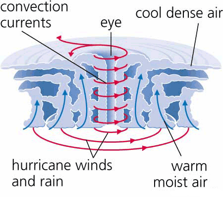
Tropical cyclones develop in the tropical regions of the world. Heat from the sun causes warm, moist air to rise into the atmosphere. As the air rises, a low pressure system forms and condensation occurs, which releases latent heat causing the air to rise further into the atmosphere. If the air pressure in the upper atmosphere is high, then the rising column of warm air will spiral outwards in the upper atmosphere and air will rush from the surface to replace it, forming a tropical cyclone.
7. What is the eye of a tropical cyclone?
Is a region of mostly calm weather found at the centre of strong tropical cyclones.
8. Draw an annotated diagram to show the main features of a tropical cyclone.
9.
What causes a tropical cyclone to be downgraded to a tropical storm?
When the warm, moist air is no longer present.
2.8 Studying the Weather
2.8 Studying the weather
1. Refer to synoptic chart and satellite image in 2.33 and 2.34:
a)
i. Hobart: 1016
ii. Port Hedland: 1010
iii. Melbourne: 1014
iv. Perth: 1018
b) Name a capital city that will most likely experience rain in the next 12hours
Port Hedland would probable experience rain in the next 12 hours.
c) Prepare a brief weather forecast for Melbourne for the next 24 hours.
Melbourne would be experiencing a fine and sunny day with a clear sky for the next 24 hours. The air temperature is quite high generally meaning it will have stable conditions
d) Name the feature shown on the synoptic chart that has caused the cloud cover at the following locations:
i. Cold fronts
ii.
e) Hobart because it has a higher pressure
2.2 Landslides, earthquakes and tsunamis
2.2 Landslides, earthquakes and tsunamis
1. What is a landslide?
A geological phenomenon which includes a wide range of ground movement, such as rock falls, deep failure of slopes and shallow debris flows, which can occur in offshore, coastal and onshore environments.
2. Describe the main causes of landslides.
Heavy rainfall saturating the soil, vibrations from earthquakes or undercutting of banks and cliffs from waves or rivers.
3. In what way can human actions contribute to landslides?
Construction of roads and railways on hillsides along with building works can weaken hillsides and make them more vulnerable during heavy rainfall.
4. What are earthquakes and how are they measured?
Earthquakes are intra-plate tension where movements occur along cracks and faults in the Earth’s crust. Earthquakes are measured in magnitude.
5. What is the main cause of earthquakes in Australia?
The main cause of earthquakes in Australia is inter plate tension
6. How frequently does Australia experience earthquakes of 5.5 on the Richter scale and why do they usually have minimal impacts on communities?
Every 15 months
7. List the impacts of the 1989 earthquake on the Newcastle community.
13 people were killed and more than 120 people were injured
8. Describe the difference between a landslide and an earthquake.
Earthquakes are bigger and effect more people.
9. What is a tsunami?
A earthquake, landslide or volcano occurs under the sea.
10. Name three events that will cause a tsunami.
Earthquakes, landslide or volcano
Earthquakes, landslide or volcano
11. With the aid of a diagram, explain how a tsunami is formed
Sudden shifting of continental places causes earthquakes forcing sea water above to rise, forming waves.
Sudden shifting of continental places causes earthquakes forcing sea water above to rise, forming waves.
12. Describe three tsunami warning signs.
Shake, drop and roar
Shake – feeling an earthquake or the ground shake in a coastal area
Drop – the seal level will recede dramatically
Roar – often a tsunami can be heard
13. What caused in Indian Ocean tsunami of 2004
An undersea earthquake measuring a magnitude of 9.3.
14. How many earthquake monitoring stations are there in Australia? How long did it take for the India Ocean earthquake of 2004 to be picked up by one of these stations?
There are 23 stations in Australia and it took 20 minutes.
There are 23 stations in Australia and it took 20 minutes.
15. Describe how a tsunami changes as it enters shallow water.
As waves near land they slow to about 45kph, they squeeze upwards, getting taller.
16. What steps has the United Nations taken to safeguard Indian Ocean communities from the tsunami hazard?
The United Nations created the tsunami warning system
17. Who is Ted Bryant? What warning does he issue in regard to tsunamis for Australia?
Ted Bryant is a Wollongong university geoscience professor. He predicted that a tsunami will come soon because every 500 or so years a tsunami occurs in the alpine fault line.
18.
a) 95 E, 5 N
b)
ii. India: 2 hours
iii. Africa: 7 hours
iv. Australia: 5 hours
v. Tasmania: 9.5 hours
Saturday, April 30, 2011
2.1 natural hazards in Australia
2.1 Natural Hazards in Australia
1. What is a natural hazard?
A threat of a naturally occurring event that will have a negative effect on people or the environment.
2. What is the difference between a natural hazard and a natural disaster?
A disaster is something that have happened. A hazard is something waiting to happen.
3. What two broad categories of natural hazard exist in Australia?
Drought and heatwave
4. Make a list of the types of natural hazards that fit each category.
5. Why are natural hazards that occur in densely populated areas more noticeable that hazards that occur elsewhere in Australia
Because the impacts they have on communities are obvious and costly which becomes well documented and covered by the media because of the effects on a large number of people.
6. Outline two specific impacts droughts have on rural communities in Australia
Economic impacts and environmental impacts
7. Name the three categories geographers use to classify the impacts of natural hazards. Give examples of each.
1. Social impacts – tsunami
2. Economic impacts – droughts
3. Environmental impacts – floods
8. Explain why it is essential that Australian communities study the nature and impacts of natural hazards.
So they can plan responses and determine better ways for communities to survive the threat of living with natural hazards.
9. Explain how GIS is used to map the threat of natural hazards in Australia.
Gis uses data to predict the areas where natural hazards are most likely to occur. Using 2573 postcodes from across Australia and data on the number of times a natural hazard has occurred in the particular postcode area. It shows the potential risk from nine different hazards.
10. Refer to 2.4 and the text
a) Tropical cyclone
b) Tropical cyclone
11. Make a list of the ways the information in 2.3 would be useful to the following groups:
a) So they know if they are located where natural hazards occur
b) So they know where about natural hazards may occur
c) Build more emergency services around places where natural hazards occur
d)
Wednesday, March 16, 2011
Australia's energy resources
1. Name three non-renewable energy resources.
Coal reserves, oil and natural gas
2. Name three renewable energy resources.
Solar power, wind power and hydro-electricity
3. Why is Australia looking to develop clean energy sources?
Because with increasing concern over the environment, and climate change Australia wants not to have serious negative impacts on the economy. Also, to save money.
4. List the top four coal producers in the world.
China, the united States, India and Australia
5. How large are Australia's coal reserves?
76 billion tonnes which will last 200 years at current production levels
6. How much natural gas does Australia have?
5 billion worth
7. Describe the solar power plant to be built near Mildura.
It will use technology developed to power satellites and consists of fields of mirrors. The Sun's energy will be concentrated using cells that produce 1500 times more energy than a typical rooftop solar panel.
8. How can electricity be generated by the wind?
Large turbines are turned by the wind, generating electricity.
9. Draw a table showing the advantages and disadvantages of the Starfish Hill wind farm.
| Advantages of the Starfish Hill wind farm | Disadvantages of the Starfish Hill wind farm |
| Supplies 18000 households with their energy needs | The farm cost $65 million |
| Represents 2 per cent of South Australia’s residential customers | Scenery won’t look as good because of all the turbines everywhere |
| Reduce greenhouse gas emissions by around two million tonnes | Turbines kill birds |
10. All these types of energy sources are all clean. All these energy sources are renewable so it will never run out. It will produce little or no waste products such as carbon dioxide or other chemical pollutants, so has minimal impact on the environment. These are really methods for energy however, these energy sources produce much less energy as for example fossil fuel generators.
14. Refer to 1.63
a) i. 17 billion
ii. 6 billion
iii. 3.5 billion
b) i. 25 billion
ii. 7 billion
iii. 3 billion
c) coal
The Earthquake and Tsunami in Japan
1. Tell me all about the recent natural disaster in Japan: (nytimes.com has some great info)

- Where was the epicentre of the earthquake?
about 80 miles off the east coast of Honshu, Japan
- What was the size of the earthquake?
The size of the earthquake has a magnitude of 8.8 to 8.9.
- What are some of the areas most effected? Describe the devastation and include an image.
The tsunami stuck Kamaishi, Kesennuma, Sendai, Fukushima Daichi Nuclear Power plant, Fukushima Daini Nuclear Power plant, Iwaki City, Onahama, Takahagi, Ichihara and Tokyo.
- Describe the impending man-made disaster: what, where , why?
There is a tsunami warning for the entire Pacific basin coastline including California and Hawaii because of the earthquake in the sea making the coastline dangerous.
Sunday, March 13, 2011
Australia's Natural Resources
1. Who is Australia's largest export partner? What products do they export with them? How much of each product do they export? For what purpose does that country need the products they import from Australia?
Australia's largest export partner is Japan. They export about US$26.4 billion (up 24.2% from prior year). They export coal, gold, meat, wool, alumina, iron ore, wheat, machinery and transport equipment. I believe that they import these from China as it would be cheaper to import these from China. i believe that we export those goods because we are a rich country which these minerals and china does not have many minerals.
2. Who is Australia's largest import partner? What do they import from them? How much? Why do you think that Australia imports these goods from this country?
Australia's largest import partner is the United States. They import about $22.4 billion (up 5.8% from 2004-5). Materials handling equipment, Civilian aircraft, Medicinal equipment, Minimum value shipments,Excavating equipment, Telecommunications equipment, Pharmaceutical preparations, Computer accessories,z Other vehicle parts & accessories. I believe that America imports these things from America because Australia is not as good at manufacturing all of these items.
- Materials handling equipment … US$876.9 million (4.9% of Australian from U.S. imports, up 46.6% from 2005)
- Civilian aircraft … $744.6 million (4.2%, up 8.3%)
- Medicinal equipment … $733 million (4.1%, up 18.3%)
- Minimum value shipments … $718.6 million (4%, up 14%)
- Excavating equipment … $714 million (4%, up 7.3%)
- Telecommunications equipment … $710.9 million (4%, up 14.5%)
- Pharmaceutical preparations … $663.7 million (3.7%, up 0.5%)
- Computer accessories … $586 million (3.3%, up 15.3%)
- Other vehicle parts & accessories … $478 million (2.7%, up 9.2%)
- Other industrial machines … $469.8 million (2.6%, up 26.3%).
Subscribe to:
Posts (Atom)