Monday, May 9, 2011

2.5 Tropical Cylcones

2.5 Tropical Cyclones

1.       What are tropical cyclones?
A localized, very intense low-pressure wind system, forming over tropical oceans and with winds of hurricane force.

2.       Where do tropical cyclones occur?
They occur in tropical regions of the world.

3.       Name the areas of Australia most at risk from tropical cyclones.
They occur over the northern areas of Australia. They generally affect areas north of Perth along the coasts of Western Australia and the Northern Territory, most of the Queensland coastline and occasionally the far north coast of New South Wales.

4.       How many tropical cyclones are expected to cross the Australian coastline each year?
Six

5.       What are some other names for tropical cyclones?
Hurricanes or typhoons.

6.       Complete the passage below.
Tropical cyclones develop in the tropical regions of the world. Heat from the sun causes warm, moist air to rise into the atmosphere. As the air rises, a low pressure system forms and condensation occurs, which releases latent heat causing the air to rise further into the atmosphere. If the air pressure in the upper atmosphere is high, then the rising column of warm air will spiral outwards in the upper atmosphere and air will rush from the surface to replace it, forming a tropical cyclone.

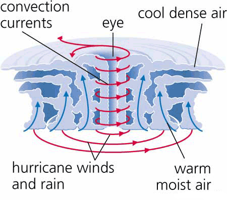
7.       What is the eye of a tropical cyclone?
Is a region of mostly calm weather found at the centre of strong tropical cyclones.

8.       Draw an annotated diagram to show the main features of a tropical cyclone.


9.    
   What causes a tropical cyclone to be downgraded to a tropical storm?
When the warm, moist air is no longer present.

2.8 Studying the Weather

2.8 Studying the weather
1. Refer to synoptic chart and satellite image in 2.33 and 2.34:
a)
i. Hobart: 1016
ii. Port Hedland: 1010
iii. Melbourne: 1014
iv. Perth: 1018
b) Name a capital city that will most likely experience rain in the next 12hours
Port Hedland would probable experience rain in the next 12 hours.
c) Prepare a brief weather forecast for Melbourne for the next 24 hours.
Melbourne would be experiencing a fine and sunny day with a clear sky for the next 24 hours. The air temperature is quite high generally meaning it will have stable conditions
d) Name the feature shown on the synoptic chart that has caused the cloud cover at the following locations:
i. Cold fronts
ii.
e) Hobart because it has a higher pressure

2.2 Landslides, earthquakes and tsunamis

2.2 Landslides, earthquakes and tsunamis

1.       What is a landslide?
A geological phenomenon which includes a wide range of ground movement, such as rock falls, deep failure of slopes and shallow debris flows, which can occur in offshore, coastal and onshore environments.

2.       Describe the main causes of landslides.
Heavy rainfall saturating the soil, vibrations from earthquakes or undercutting of banks and cliffs from waves or rivers.

3.       In what way can human actions contribute to landslides?
Construction of roads and railways on hillsides along with building works can weaken hillsides and make them more vulnerable during heavy rainfall.

4.       What are earthquakes and how are they measured?
Earthquakes are intra-plate tension where movements occur along cracks and faults in the Earth’s crust.  Earthquakes are measured in magnitude.

5.       What is the main cause of earthquakes in Australia?
The main cause of earthquakes in Australia is inter plate tension

6.       How frequently does Australia experience earthquakes of 5.5 on the Richter scale and why do they usually have minimal impacts on communities?
Every 15 months

7.       List the impacts of the 1989 earthquake on the Newcastle community.
13 people were killed and more than 120 people were injured

8.       Describe the difference between a landslide and an earthquake.
Earthquakes are bigger and effect more people.

9.       What is a tsunami?
A earthquake, landslide or volcano occurs under the sea.

10.   Name three events that will cause a tsunami.
Earthquakes, landslide or volcano

11.   With the aid of a diagram, explain how a tsunami is formed
Sudden shifting of continental places causes earthquakes forcing sea water above to rise, forming waves.


12.   Describe three tsunami warning signs.

Shake, drop and roar
Shake – feeling an earthquake or the ground shake in a coastal area
Drop – the seal level will recede dramatically
Roar – often a tsunami can be heard

13.   What caused in Indian Ocean tsunami of 2004
An undersea earthquake measuring a magnitude of 9.3.

14.   How many earthquake monitoring stations are there in Australia? How long did it take for the India Ocean earthquake of 2004 to be picked up by one of these stations?
There are 23 stations in Australia and it took 20 minutes.

15.   Describe how a tsunami changes as it enters shallow water.
As waves near land they slow to about 45kph, they squeeze upwards, getting taller.

16.   What steps has the United Nations taken to safeguard Indian Ocean communities from the tsunami hazard?
The United Nations created the tsunami warning system

17.   Who is Ted Bryant? What warning does he issue in regard to tsunamis for Australia?
Ted Bryant is a Wollongong university geoscience professor. He predicted that  a tsunami will come soon because every 500 or so years a tsunami occurs in the alpine fault line.

18.    
a)      95 E, 5 N
b)       
ii. India: 2 hours
iii. Africa: 7 hours
iv. Australia: 5 hours
v. Tasmania: 9.5 hours